SSEN to create 3D overhead lines model
Scottish and Southern Electricity Networks (SSEN) has revealed plans to create a detailed 3D visualisation of its overhead lines networks to enhance resilience and maintenance efficiency.
5th December 2016 by Networks
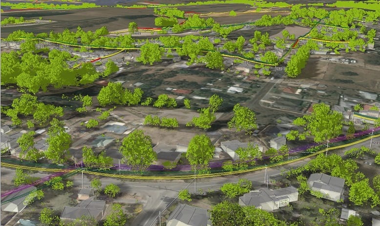
To create the 3D network model SSEN is working with infrastructure technology partner NM Group to conduct wide ranging aerial surveillance of its assets.
The aircraft deployed by SSEN and NM Group are equipped with the latest in LiDAR (Light Detection and Ranging) technology which is able to identify SSEN’s 63,000km and create detailed maps which include information such as cable height and the proximity of potential hazards such as vegetation. The technology is so detailed, in some areas, it can give distances as little as 2cm.
SSEN will use the 3D maps generated from the LiDAR data to plan an effective tree cutting programme and deliver wider maintenance work. SSEN’s head of asset management and innovation said this will have a “significant” impact on network resilience. He added: “It will help ensure we are able to identify and mitigate any risks and allow us to rectify any problems. This should result in a better security of supply to our customers.”
The detailed asset data captured during aerial scanning will also influence future investment planning and connections activity.
SSEN is not using regulated innovation funds to support deployment of this technology which it believes is mature and market ready.
NM Group has started to scan SSEN’s network and it will complete the first stage of the project in March 2017.
Comments
Login on register to comment
Related content

Power
Utilities mobilise coronavirus vulnerability support
£800,000 of support has been offered to support those struggling as a result of the pandemic
Power
ENA champions network key workers in new campaign
Trade body justifies continued presence of network staff in customer communities
Power
Surge in popularity for ‘Power Up’ safety website as parents teach at home
UK Power Networks' free website designed to help children stay safe around electricity has seen its visitor numbers rise by more than 90%
Related supplier content
![‘Learning by doing’ on the road to net zero [test product]](https://networksonline.s3.amazonaws.com/products/images/3.jpg)
People & Skills
‘Learning by doing’ on the road to net zero [test product]
DSO director Andrew Roper discusses 'Learning by doing'

Power
Load patterns and lockdown: how Covid-19 is impacting electricity networks
Insights into dynamics on the low voltage network as the outbreak unfolds
Downloads
Protect electrical equipment from insulation failure
Insulation faults are a major cause leading to the eventual failure of electrical equipment. Partial discharge (PD) is a very reliable indicator of developing insulation faults. Regular PD testing allows users to detect and analyze PD activity